
Getting Around Palm Springs Without a Car
Yes—getting around Palm Springs without a car is practical for many central trips when you combine walking, SunLine buses and rideshare by journey. Base each choice on the actual destination entrance, walking conditions, current bus route and timetable, and a workable return option; farther or awkwardly accessed attractions often need a separate rideshare or transit connection.

Car-free trip decision guide
Plan each sightseeing leg from the destination and return trip backwards. The best mode changes with access, timing and the route you actually need to use.
- Find the real endpoint.Use the visitor entrance or practical drop-off point, not the map pin alone.
- Group only usable nearby stops.Cluster destinations when the walking route or transport connection between them is genuinely practical.
- Test the simplest mode first.Walk when the route and conditions are manageable; use SunLine when the stop, direction and timetable align.
- Close the return leg before leaving.Use rideshare or another verified option when a bus or walking return is not workable, especially in the evening or for less-central destinations.
- Walk
- Best for compact legs with usable sidewalks and crossings, manageable heat exposure and a practical return.
- SunLine bus
- Best when the correct stop and direction, current timetable, any transfer and the return service all fit the trip.
- Rideshare
- Best for direct or flexible connections when pickup and drop-off access, current availability, wait and quoted cost are acceptable.
- Separate transport leg
- Use when the final mile, route alignment or return timing breaks an otherwise convenient sightseeing cluster.
Decision rule: a trip is only as practical as its least workable leg—outbound, final mile or return.
Table of Contents
Plan Sightseeing by Area and Travel Distance
Car-free sightseeing in Palm Springs is easier when you group nearby stops before choosing transport.
Use the actual entrance and usable route between stops, not map-marker distance alone.
Screen each cluster for proximity, realistic walking conditions, distance from central Palm Springs, transport availability and a workable return at the time you plan to travel.
Staying near the places you expect to visit can reduce repeated transport legs, but accommodation location does not remove the need to verify each longer journey.
Use these criteria to separate stops that can share one practical sightseeing cluster from stops that need their own transport leg:
- Proximity: Group nearby stops when their actual access points allow a practical transfer rather than relying only on map proximity.
- Realistic walking conditions: Treat walking distance as conditional on the usable route, heat exposure, and timing rather than applying one unsupported fixed threshold.
- Destination entrance: Check the usable destination entrance or access point because the practical approach may differ from the apparent map position.
- Route alignment: Keep stops in the same cluster when the available route fits the required direction of travel; otherwise, plan a separate transport leg.
- Transport availability and timing: Confirm that a workable transport option serves the required transfer when it is needed.
- Return leg: Treat a destination as a separate journey when reaching it is practical but the planned return trip lacks a workable transport option.
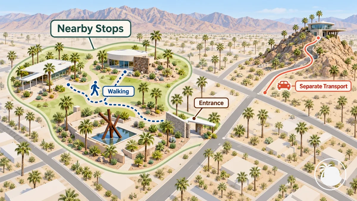
Two Palm Springs destinations can look close on a map yet require different transport plans when their usable entrances use different approaches, the pedestrian connection is poor, or the return timing makes the combined route impractical.
Cluster stops by usable access and return feasibility first; then assign walking, bus or rideshare to each leg. Detailed multi-day sequencing belongs in itinerary planning.
Choose Between Walking, Local Buses, and Rideshare
Walking, SunLine buses and rideshare solve different Palm Springs trip conditions; there is no single best mode for every leg.
Walking fits compact routes with practical pedestrian conditions; SunLine works when the stop, direction, route and timetable align; rideshare suits direct or flexible connections when pickup, drop-off and current availability are workable.
Compare each option on the same attributes: door-to-door reach, schedule dependence, flexibility, wait uncertainty and cost predictability.
The comparison below keeps those attributes constant so the operational trade-offs are easy to see.

| Mode | Best-fit trip | Door-to-door reach | Schedule dependence | Flexibility | Wait uncertainty | Cost predictability |
|---|---|---|---|---|---|---|
| Walking | Compact trips where distance and conditions make walking practical | Direct when pedestrian access reaches the destination | No timetable dependency | Flexible within practical walking conditions | No vehicle wait | No transport fare |
| SunLine bus | Trips where a useful route and timetable align with the destination | Depends on stop location and any walking needed at either end | Requires route and timetable alignment | Constrained by available routes and service timing | Linked to scheduled service and any transfer conditions | More predictable when the applicable fare is known before travel |
| Rideshare | Direct or flexible trips where pickup service is available | Can provide pickup and drop-off near the requested locations when road access permits | No fixed public-transport timetable | Flexible when a ride is available | Wait time varies with driver availability and demand | Quoted trip cost can vary with trip and demand conditions |
Choose the mode by the leg, not by the whole visit. Walk within a compact practical cluster, switch to SunLine when the route and timetable fit, and use rideshare when you need a direct or more flexible connection.
Know When Walking Beyond Downtown Is Practical
Walking beyond downtown Palm Springs is practical only when the specific route, conditions, timing and return all support it.
Distance alone is not enough: sidewalk continuity, street crossings, heat exposure and shade can make two routes of similar length very different to walk.
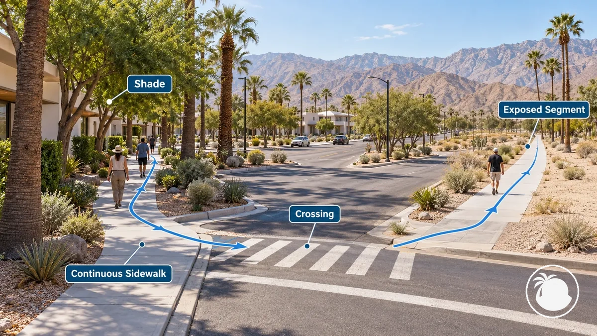
Evaluate the full walking leg under the conditions in which you will actually use it, not only the distance shown on a map.
These criteria indicate when a route remains practical to walk and when another transport mode may be more suitable:
- Distance: A shorter route can support walking when the rest of the route conditions are practical, while a longer leg increases the amount of exposure and effort involved.
- Sidewalk continuity: A continuous usable sidewalk supports a more straightforward walking route; gaps or indirect pedestrian routing can make the leg less practical.
- Crossings: Check how the route handles street crossings, because the usable pedestrian path may differ from the most direct line on a map.
- Heat and shade: Greater heat exposure and limited shade can make the same walking distance less practical, particularly when conditions are hotter.
- Time of day: Walking practicality can change with environmental conditions and the timing of the trip, so assess the route for the period when it will actually be used.
- Return option: Confirm whether the return trip remains practical on foot or whether another transport mode is available if conditions or timing make walking back unsuitable.
Downtown can provide compact walking conditions, but it does not prove that a route beyond downtown is equally walkable.
Check the mapped distance against the actual pedestrian route and the return option before committing to the walk.
Use SunLine Buses When Routes and Schedules Match Your Stops
SunLine buses provide local public transport in Palm Springs and across the Coachella Valley. For a sightseeing trip, use the bus only when the route, stop, direction, timetable and return service align with the destination.
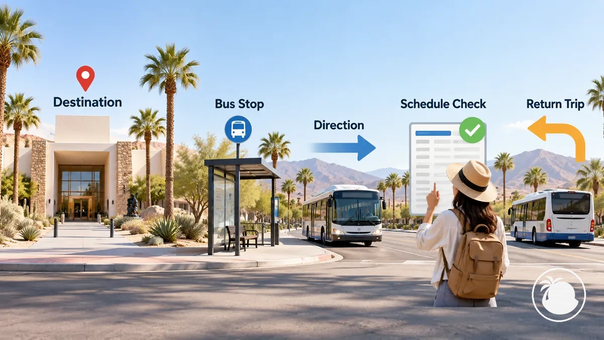
Verify the trip with current SunLine information because routes, service frequency, fares and accepted payment methods can change.
Work from the destination entrance through the route and schedule checks in this order:
- Identify the destination entrance: Confirm the entrance or access point you actually need to reach so the bus trip is evaluated against the correct final location.
- Find a usable stop and direction: Locate a stop serving the required direction and check the walking connection between that stop and the destination entrance; a nearby stop is useful only when it serves the correct direction and provides a workable final approach.
- Verify transfer needs: Check whether the trip requires a transfer and whether the connecting service fits the journey; an inconvenient or poorly aligned connection can make the bus trip less practical.
- Check the outbound timetable and return service: Confirm the planned departure, applicable service frequency, and a workable return trip for the time of the visit. A route that reaches the destination is not sufficient if its schedule does not support both outbound and return travel.
- Confirm current fare and payment details: Check SunLine's current information for the applicable fare and accepted payment method before boarding rather than relying on older route or fare information.
For example, a Palm Springs attraction can be practical to reach by SunLine when a usable stop serves the correct direction near its entrance and the timetable supports both the visit and return service.
If the bus reaches the general area but the stop, transfer or return timing fails, do not treat the route as a complete solution; confirm a workable alternative for the broken leg.
Use Rideshare for Direct or Flexible Connections
Rideshare can bridge a Palm Springs transport gap when a direct trip or flexible departure time is more practical than walking or the available bus service.
Its usefulness depends on pickup access, destination access, current availability, expected wait and the return plan.

Rideshare availability, wait time and quoted price are time- and location-dependent. Demand—including events or busy periods—can change supply and expected wait, while both pickup and destination must allow practical vehicle access. Uber and Lyft are examples of ride-hailing services, but app estimates should be treated as current trip conditions rather than fixed values.
- Pickup access: Use a pickup point where the requested vehicle can practically reach you; an awkward pickup area can make the connection less workable even when rideshare service is available nearby.
- Destination access: Check whether the destination has a practical vehicle approach or drop-off point so the direct trip reaches the location you actually need.
- Demand and timing: Expect availability to depend on location, time, and current demand, including periods when local events may increase ride requests.
- Wait variability: Treat the displayed or expected wait as a current trip condition rather than a guaranteed arrival time because driver availability and demand can change.
- Return option: For a less central destination, confirm that a workable return option is available for the intended departure time rather than assuming a rideshare will be available later.
Airport-specific pickup and arrival procedures belong with airport arrival transport rather than local sightseeing rideshare planning.
For local sightseeing, make the decision from the pickup point, destination access, timing and a confirmed return option—especially for less-central destinations.
Reach Attractions That Are Difficult to Access Without a Car
An attraction can look nearby on a map yet be difficult to reach without a car when the practical transit stop or rideshare drop-off is separated from the visitor entrance by an awkward final-mile segment or a weak return connection.
The real endpoint is the visitor entrance, not the attraction's map pin. Verify the arrival point, final mile and return conditions before deciding that the trip is practical.
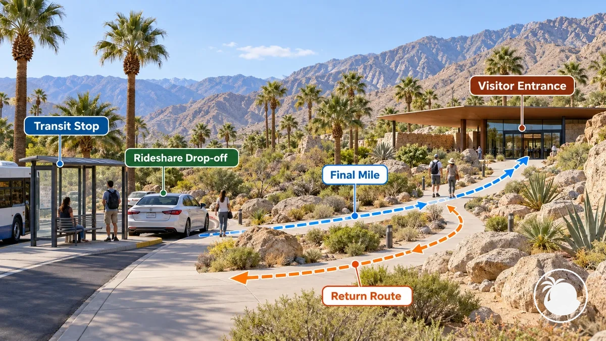
Test the complete access chain: arrival point → final mile → visitor entrance → return.
The following checks determine whether the stop, drop-off, final mile, and return time form a workable connection:
- Locate the actual visitor entrance: Identify the entrance or access point visitors need to reach, because the attraction's general map location may not represent the practical endpoint of the journey.
- Identify the arrival point: Find the nearest realistic transit stop or rideshare drop-off that serves the required approach to the attraction, rather than assuming the geographically nearest point provides usable access.
- Assess the final mile: Examine the last segment between the transit stop or rideshare drop-off and the visitor entrance, including whether that segment can be completed by the intended method.
- Verify operating and return constraints: Check the attraction's applicable operating time alongside the transport schedule or expected return option so the outward journey does not leave an impractical return connection.
- Choose the workable connection: Select the transport method only after the entrance, arrival point, final-mile segment, and return time align into a feasible journey.
Choose the transport only after both the final-mile segment and the return plan are workable.
Plan Evening Transport Around Bus Hours and Rideshare Availability
A transport option that works by day does not automatically work in the evening because bus departures, route direction, rideshare supply and pickup conditions can be different later.
Check the outbound and return legs separately against the actual time of travel.
For buses, the decisive values are the relevant departure and correct direction; for rideshare, availability and expected wait remain dependent on location, time and demand.
The following checklist verifies whether the evening journey has a workable path in both directions:
- Latest relevant bus departure: Confirm the applicable departure for the planned return time so the trip does not rely on a bus that no longer fits the schedule.
- Correct route direction: Verify that the relevant departure serves the direction needed for the return trip rather than assuming an outbound route works identically in reverse.
- Pickup location: Identify a practical pickup point for the return journey so a rideshare request can be made from a location vehicles can reach.
- Rideshare availability: Check availability for the relevant location and time because the presence of rideshare service earlier in the day does not guarantee supply for the return trip.
- Expected wait variability: Treat the displayed or expected wait as time- and demand-dependent rather than a guaranteed pickup time, and allow for that uncertainty in the evening plan.
- Backup plan: Confirm a return alternative that remains workable if the intended bus timing or rideshare availability no longer aligns with the trip.
For example, an outbound bus can be workable when its route and departure align with the destination, while the return trip may require rideshare if the relevant later bus service does not fit the planned departure from the destination.
Conversely, rideshare can serve the outbound leg while a suitable bus departure provides the return when its timing and direction align.